Marwell South Master Plan Design
Background: Whitehorse, the capital of Yukon Territory, has a population of around 32,500, making up 68.5% of Yukon's population. It is the economic hub for the territory and parts of British Columbia, with government jobs, mining, and construction as key economic drivers. Located by Chu Nìikwän/the Yukon River and surrounded by mountains, Whitehorse is also a tourist gateway to the Yukon and Alaska. The city is located on the traditional lands of the KDFN and Ta'an Kwäch'än Council (TKC), both of which hold significant Settlement Land within the city limits and have initiated development on these lands. YG is the largest developer in Whitehorse, mainly operating through its Land Management Branch. Private sector development is currently centered on infrastructure and buildings, with future opportunities for subdivision development.
Project Abstract: Whitehorse is experiencing significant growth, with a projected population increase of 42% by 2040. In response, the city's 2023 Official Community Plan (OCP) sets a minimum density target of 20 units per gross hectare for any proposed residential or residential related areas, while also promoting the redevelopment of brownfield sites.
One such opportunity for redevelopment has emerged in the Marwell Industrial Area, as North 60 Petro, a bulk fuel supplier, is planning to relocate its facility. The surrounding site includes major warehouses and outdoor storage facilities owned by the Yukon Government (YG), which also plans to relocate in the medium term, alongside a smaller city-owned warehouse. The Kwanlin Dün First Nation (KDFN) holds Settlement Land nearby and has the first right of refusal for a substantial portion of YG lands, further enhancing the potential for coordinated development. Additionally, 16 private landowners adjacent to the site have an opportunity to reconsider the use of their lands in light of the area’s redevelopment.
This presents an opportunity to master plan approx. 37.2 ha of brownfield area next to the downtown and the river. The 2018 Marwell Plan and the OCP envision the redevelopment of this area to support more intensive land uses, leveraging its strategic proximity to the downtown core. However, this site presents several challenges. Its low elevation has historically made it susceptible to flooding, with the most recent event occurring in 2021. Quartz Road, a major arterial route bisecting the area, is already at or beyond capacity, as it serves as a vital connection for residents from the northern neighborhoods of Porter Creek, Whistle Bend, and Range Point to downtown Whitehorse. Moreover, the industrial history of the area has led to contamination that will need to be addressed during redevelopment.
This project aims to develop land use concepts that will guide and encourage the redevelopment of this key brownfield area, transforming it into a vibrant, sustainable, and integrated part of Whitehorse’s urban landscape.
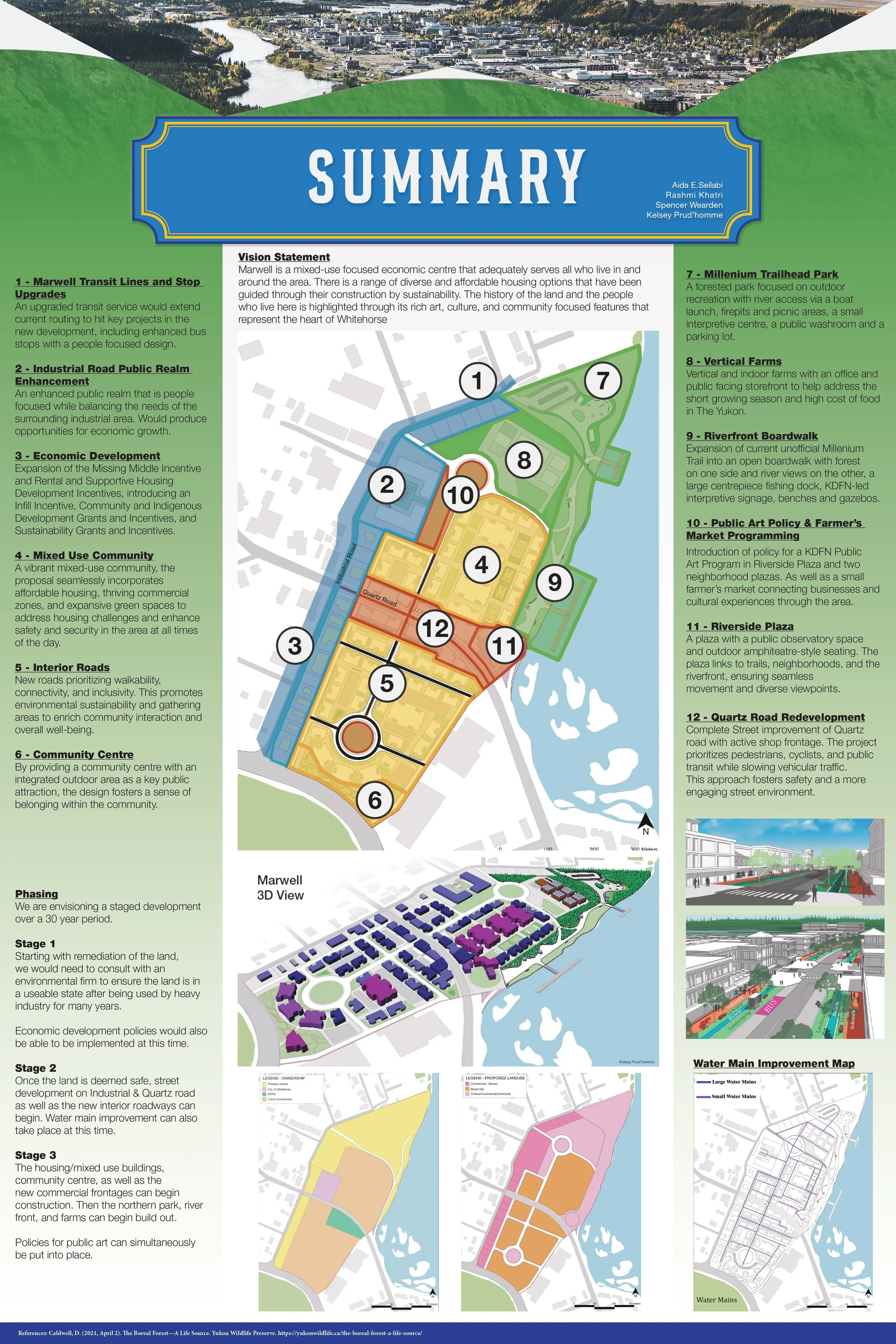
The study area includes the southern portion of the Marwell Industrial Area, which is generally bound by Industrial Rd., Chu Nìikwän/the Yukon River, the Walmart/Canadian Tire rear lot lines, and Two Mile Hill (see attached map). The planning process needs to consider City plans, policies, and bylaws, as well as environmental constraints, heritage buildings, transition to adjacent uses, access, density and types of uses, and the surrounding context.